By Louie Stout
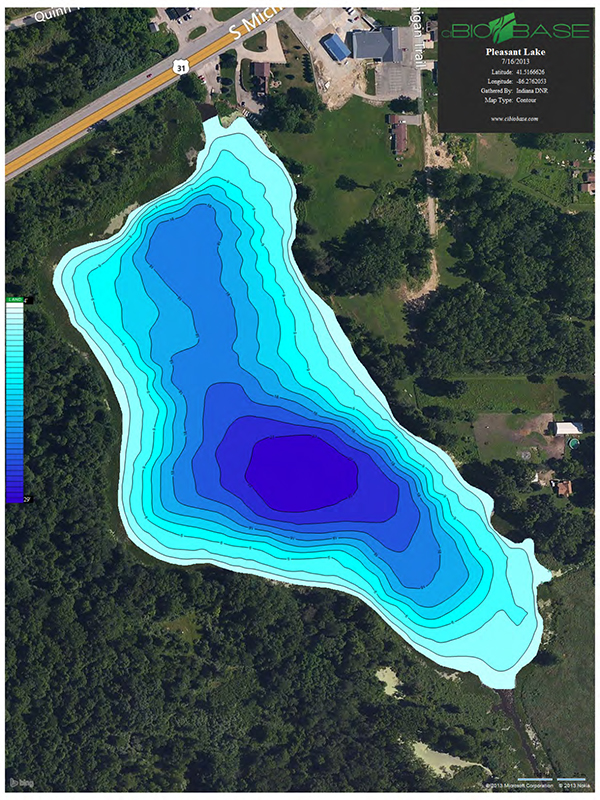 New Lake Maps Will Help Indiana Anglers
Lake contour maps have long been one of the most valuable tools fishermen can use to find potentially productive areas.
Those topographic maps will show you instantly where the big flats lie, where the lake bottom plunges into the abyss, and fish holding structures like underwater points and submerged islands.
Game fish use bottom contours as highways to and from feeding or comfort areas. Often times they will school on an irregular feature, such as a point, an inside turn of a drop-off, or on offshore humps. If you have knowledge of the seasonal patterns of each fish species, map study can lead you to those most productive areas.
Both Indiana and Michigan provide free maps of public lakes online that you can access with a computer and print off as many copies as you want. Many of those lakes have been added to modern day fishfinder units that offer mapping and GPS capabilities.
However, a historic problem with DNR maps is that many are outdated. A lot of the northern Indiana and southern Michigan inland lakes were mapped 60 years.
They now are inaccurate due to erosion, sedimentation and manmade changes that have occurred over the years.
But that’s changing. The Indiana Fisheries Research Division has been aggressively remapping northern lakes and posting them on the DNR’s website. As of now, those maps haven’t been made available to the electronic mapping companies for use in fish finders. However, you can still pull up the map on your smart phone while on the water or print them out from a home computer.
The methodology is pretty interesting. When fisheries personnel visit a lake to do studies, they utilize Lowrance HD GPS units on state boats to conduct bathymetric surveys and record lake bottom depth readings, vegetation content and bottom hardness. That information is saved to an SD card and uploaded into an office computer and shipped to a private company that prepares the maps.
Several of those newer maps can be found on the DNR website http://www.in.gov/dnr/fishwild/5759.htm. The ones that have been updated are designated as “bathymetry map,” and each one of those is dated so you know which was updated most recently.
Northern Fisheries Supervisor Jeremy Price said his crews will be working with newer technology this year which should make the maps even better.
For example, the contour lines will be sharper and the varying degrees of depths will be color shaded (blue) so that shallower water will stand out more prominently than deeper water.
The bathymetric maps will provide the DNR with documentation of where there is vegetation and hard bottoms, but the public maps will only show depths.
The DNR plans to remap 20 lakes a year. Among the newest lakes mapped that will be added to the DNR site in a few weeks include Worster Lake in St. Joseph County; Hoffman, Pike and Little Pike in Kosciusko County; Hog Lake in LaPorte County; and Cass Lake in LaGrange County.









Connect With Us